
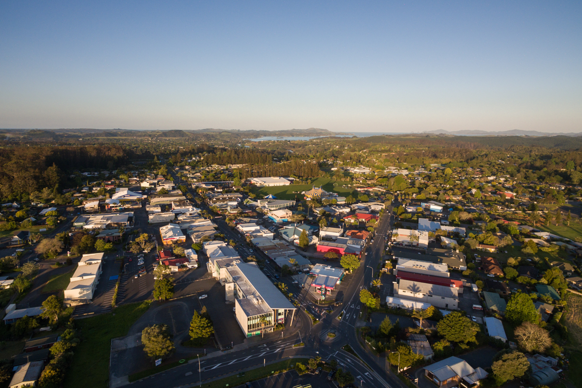
Te Pātukurea - Kerikeri Waipapa Spatial Plan
For public consultation under the Special Consultative Procedure of the Local Government Act 2002
Have we got it right? / E tika ana rānei tā mātou
In 2024, we asked you what you thought the future of Kerikeri and Waipapa should look like.
Using your feedback, we have created a draft plan, Te Pātukurea, which will shape how these areas grow and develop over the next 30+ years.
Now, we’re coming back to you to make sure we’ve got it right.
Here’s what we are proposing / Anei tā mātou e whakatakoto nei
Some of the key elements in the draft plan include:
- Providing for the development of townhouses, duplexes and small apartments in the centres of Kerikeri and Waipapa.
- Creating opportunities for new transport connections, parks and green spaces, and recreational and community facilities along with improvements to the health of waterways and biodiversity.
- Allowing for more commercial development in both Kerikeri and Waipapa.
- Redirecting growth into the centres of Kerikeri and Waipapa rather than in rural areas.
Click to see an interactive draft spatial plan and have your say
We’re coming to you / E tae atu ana mātou ki a koe
Thanks for coming along to the many pop-up events held across the area—we’ve loved hearing your thoughts on the draft spatial plan!
All of our events have now wrapped up.
We hope to see you there.
Have your say / Kōrerotia mai ōu whakaaro
You can also tell us what you think of the draft spatial plan:
- Online submissions: Click here to have your say
- Email us: kwsp@fndc.govt.nz
- In person: Drop off a submission form at any FNDC service centre or library. (Our friendly customer service team can also print it for you.)
- By mail: Far North District Council, Private Bag 752, Kaikohe 0440
- Directly to councillors: on 1 & 2 May 2025 at the Turner Centre in Kerikeri. If you wish to do this, please select 'I wish to present my submission verbally’ on the submission form and our team will be in touch.
We must receive your submission by April 22, 2025.
Frequently asked questions
We've received a number of follow-up questions from community groups and potential submitters seeking further clarification on the draft spatial plan and on the process we’re following to gain feedback from the public on the draft. In response, we’ve prepared this set of Frequently Asked Questions (FAQs) to highlight where these topics are already addressed in the draft spatial plan and associated documentation. If you’ve already made a submission but would like to update or expand on it after reading these FAQs, you’re welcome to make an additional submission. The submission period is open until 22 April 2025.
We're creating a plan for the future of Kerikeri-Waipapa, Te Pātukurea, which will shape how these areas grow and develop over the next 30+ years.
The plan will influence:
- The look and feel of our communities
- Where and how we live
- How we get around
- Where we work
- How we protect and care for our environment
Right now, Te Pātukurea is in a draft phase. We need your feedback to make sure we’ve got it right before we can finalise it and present it to Council for adoption.
No, the current version of Te Pātukurea is a draft only. It has been developed using the feedback you provided in 2024 about what is important for the future of Kerikeri and Waipapa. We are coming back to you know to make sure we’ve got it right and the plan reflects the aspirations of the community.
We’ll take the submissions you provide on the draft spatial plan and use it to make any changes needed to the plan before finalising it.
Once it is finalised, the plan will be presented to Council for adoption in mid-2025.
In 2024, we shared six growth scenarios with you which considered what the future could look like for Kerikeri and Waipapa. We asked you to tell us which scenario you preferred and why, and what an ideal future for Kerikeri and Waipapa looked like to you.
In total, we received 771 pieces of feedback including:
- 187 online survey responses
- 176 comments on the interactive have-your-say scenario mapping tool
- 16 hard-copy surveys
- 208 comments / responses via social media
- 17 letter submissions via email
- 88 post-it notes on growth scenario maps at events
- 95 people included in rangatahi engagement sessions
A big thank you to everyone who provided their feedback.
In 2022, in partnership with Te Pātukurea Hapū Rōpū, and in consultation with partners, stakeholders and community groups, we began the development of the Te Pātukurea. This started with the development of a vision, emerging themes and aspirations as well as initial scenario-testing.
Then, in 2023, we went out to the community to test these themes and aspirations to understand if we've got them right and to check if we've missed anything. We also reviewed submissions to the Proposed District Plan. The original submission period for the Proposed District Plan was in 2022 and further submissions in 2023.
Using this feedback and underpinning it with evidence, in 2024, we developed several growth options which tested different possible futures for Kerikeri-Waipapa. This feedback has been used to shape the draft spatial plan and we are now looking to get your input again so we can make sure we’ve got the plan for our future right.
We’ll use your feedback from this final round of engagement to update and finalise the spatial plan before it is presented to Council in mid-2025 for adoption.
Under the current consultation (Special Consultative Procedure) on the draft spatial plan, each submission is counted once, whether it represents an individual or a group. This ensures fairness and avoids giving groups more weight than individuals. However, Elected Members have the opportunity to read and consider all submissions and may choose to consider who made a submission when weighing feedback.
Survey questions for the draft spatial plan have been developed in consultation with internal and external communications and planning experts. These questions are designed to gather community input to refine:
- Areas identified for future growth
- Urban design principles
- Implementation priorities
We are currently seeking feedback on the draft spatial plan, and welcome suggestions for changes. All submissions will be presented to Elected Members to help inform the final version of the plan.
The final spatial plan, if adopted, and any implementation plan will be updated to reflect any amendments made as a result of consultation. Where appropriate, some actions may be brought forward ahead of the currently proposed timeframes.
Ongoing Community Engagement & Consultation
Te Pātukurea’s draft implementation plan identifies additional planning tools needed to deliver the draft spatial plan’s objectives, including:
- Waipapa Structure Plan (2025–26)
- Urban Design Framework (2026)
- Waipapa Neighbourhood Plan (2026)
- Kerikeri Structure Plan (2027)
- Kerikeri Neighbourhood Plan (2029–35)
Each of these projects will have its own communications and engagement strategy developed prior to commencement. The community and stakeholders will be engaged as part of each of these future planning projects.
Stakeholder Engagement
Stakeholders have been actively involved throughout the project. A stakeholder mapping exercise was completed at the outset to identify:
- Individuals or groups with high interest or influence (e.g. developers, community groups, government agencies)
- Those directly affected by the plan
The development sector was specifically engaged through:
- Two workshops on the spatial plan
- A separate workshop to inform the Housing and Business Capacity Assessment (HBA)
Voluntary Alignment with National Policy
Although Council is not a Tier 1 or Tier 2 council and is not required to prepare a Future Development Strategy under the National Policy Statement on Urban Development (NPS-UD), we have voluntarily followed its guidance and taken an evidence-based approach to long-term growth planning.
Participation Rates and Feedback
Public consultation on the growth scenarios in November 2024 resulted in 187 completed surveys, a 1.3% response rate. For comparison:
- Councils most recent Long Term Plan consultation had a 0.7% response rate (506 submissions)
- The Auckland Future Development Strategy received 10,083 responses — about 0.6% of Auckland’s 1.7 million population
The consultation period for Te Pātukurea runs until 22 April 2025. We encourage everyone to have their say — all feedback matters and helps shape a plan that reflects the community’s needs and aspirations.
Key Principles Behind the Growth Scenarios
Community consultation in late 2023 helped identify the aspirations, challenges, and emerging themes for Kerikeri–Waipapa, which shaped the objectives of Te Pātukurea. To deliver on these objectives, a set of guiding principles (outlined in the Foundation Report) was developed to inform the growth scenarios and support decision-making.
1. Planning for Higher Growth
We’ve taken an aspirational approach by planning for higher-than-expected growth to ensure there is sufficient land for housing, business activities, and supporting infrastructure as demand increases.
2. Protecting Horticultural Land
To safeguard the district’s most productive soils, areas with Land Use Capability (LUC) 1 and 2 that meet the definition of Highly Productive Land under the National Policy Statement for Highly Productive Land (NPS-HPL) are mapped as Wāhi Toitū (no-go) areas. This includes land proposed to be zoned for horticulture in the Proposed District Plan.
LUC 3 soils meeting the NPS-HPL definition (i.e. located in general rural or rural production zones) are mapped as Wāhi Toiora (go carefully). While LUC 3 is currently protected under the NPS-HPL, the government has indicated it may remove LUC 3 protection and consult on which areas should be retained for special agricultural zones. For this reason, Te Pātukurea treats LUC 3 as constrained for future urban development.
3. Supporting Intensification
To limit sprawl and protect rural land, the plan promotes intensification within existing urban areas where appropriate. This approach:
- Makes better use of existing infrastructure
- Supports more diverse and affordable housing options
- Enhances the vibrancy of town centres
4. Strengthening Local Identity
While Kerikeri–Waipapa has a rich history, feedback shows that the current built environment doesn’t reflect the diversity or cultural aspirations of the community. Strengthening local identity is key to building a place people are proud of.
- For Kerikeri, the focus is on maintaining its village character while growing its role as a cultural and heritage destination.
- For Waipapa, the aim is to evolve into a commercial, industrial, and district-wide sports hub.
Assessing the Growth Scenarios
The Growth Scenarios Evaluation Report explains how each option was assessed before the draft spatial plan (Te Pātukurea) was developed. A neutral, consistent approach was applied across all scenarios, using current environmental conditions and required infrastructure to assess each one.
To ensure objectivity, Council staff did not promote the benefits of any scenario, although the future of each scenario was explored using personas. Independent planning consultants Beca assisted staff with technical input, and the draft spatial plan was peer reviewed by Boffa Miskell.
Each growth scenario was evaluated using four different methods:
- Infrastructure cost analysis: Scenarios were ranked based on cost and constraints
- Subject Matter Expert multi-criteria assessment (MCA): To understand how different options compare against a set of criteria when scored by subject matter experts.
- Hapū Rōpū Cultural Analysis.
- Community engagement on all scenarios: Our community was asked how well they felt each scenario aligned with their vision for the future of Kerikeri-Waipapa.
Together, these methods provided a broad foundation that enabled objective consideration of the scenarios from multiple perspectives.
The evaluation process was completed in stages, allowing us to complete parts of the analysis while community engagement was underway. The first stage included the completion of the infrastructure cost analysis, the MCA and the Hapū Rōpū Cultural Analysis. The results of this stage were then reviewed in light of feedback from engagement.
The combination of Scenarios D and E was chosen as the preferred growth approach because it provides a balanced framework for the future of Kerikeri-Waipapa. Scenario D supports Kerikeri’s role as a cultural and commercial centre, while Scenario E strengthens Waipapa as a key business and employment hub.
Why the Scenario Assessment Criteria Weren’t Weighted
In developing the draft spatial plan several growth scenarios were assessed. As part of the assessment, a ‘multi-criteria assessment’ (MCA) tool was used. An MCA is a common tool that is used to assist decision-making process and provides an opportunity to understand how different options compare against a set of criteria. Detail on how the tool was developed and used is available in the Growth Scenarios Evaluation Report. No weights were applied to the multi-criteria analysis, for several reasons:
- Weighting is subjective and can introduce bias.
- Objectives were considered equally important.
- Criteria may change in relevance over time.
- Weighting can complicate interpretation, especially for the public.
Cost Recovery and Funding
Council is currently considering its approach to development funding including the potential adoption of a Development Contributions/ Levies policy and Financial Contributions under the Resource Management Act. A funding and financing strategy for any spatial plan adopted will be developed through the draft implementation plan to explore ways to reduce reliance on rates. Cost recovery from developers has not been considered as part of the development of the draft spatial plan given the long-term nature of spatial planning, the need for flexibility and uncertainty around costs in the absence of specific approved projects.
Public Transport and Reducing Car Dependence
Introducing public transport to Kerikeri-Waipapa will depend on factors like demand, cost-effectiveness, and existing alternatives such as ride-sharing. Best practice shows that compact urban areas make public transport more viable and efficient—something Te Pātukurea aims to support.
Compact development also encourages walking and cycling, making active transport a realistic option for many. Growth scenarios that located housing near jobs and major roads scored highest in our assessments, as they are best suited for efficient public transport. Scenarios with more spread-out development were less favourable.
Road Network and Traffic Management
There is concern about whether the current road network can handle future growth. Transport modelling shows that Kerikeri-Waipapa’s roads can cope with projected demand through to 2032, with travel time increases of one minute or less during peak hours. Most intersections are expected to have sufficient capacity.
To support network resilience, the draft spatial plan outlines a long-term vision for transport improvements, including new connections, upgraded roundabouts, and improved road links to improve traffic flow and dispersal. While exact routes aren’t finalised yet, these would be detailed in future structure planning. The CBD bypass project is underway to improve traffic flow through central Kerikeri and a connection between Mill Lane and Hall Road is being planned.
Focusing development around existing centres and walkable areas supports reduced car use, encourages active transport, and strengthens the case for public transport in future.
New Developments and Network Impact
Approval of large-scale developments will inevitably add to traffic volumes. While this has been considered in our modelling, developers will still be required to submit traffic impact assessments to show how their projects will affect the network and what mitigation may be needed. For further information see Te Pātukurea – Statement of Proposal.
Te Pātukurea identifies the need for significant infrastructure upgrades, including:
- Improvements to the transport network
- Upgrades to three waters infrastructure (drinking water, wastewater, and stormwater)
- Ongoing road maintenance and renewals
Specific details are available here – Te Pātukurea - Statement of Proposal.
Planned transport improvements focus on:
- Supporting future public transport options
- Expanding cycling infrastructure
- Enhancing connectivity to reduce traffic congestion and serve a growing population
- Enhanced blue-green networks including riverside walking tracks
The goal is to create a balanced and sustainable transport system that meets the needs of current and future residents.
Te Pātukurea has allowed for additional land to accommodate new community facilities such as parks, recreational areas, community centres. As areas within the spatial plan are developed or re-developed, provision will be made for community facilities, however providing these facilities ultimately depends on the pace of growth and change. The draft spatial plan also includes adequate provision for social infrastructure, such as healthcare and education facilities by ensuring sufficient land area is included.
It is important to note that the projects and initiatives identified in this plan are unfunded at this stage.
Delivering Te Pātukurea: Implementation and Timing
At this stage, these projects are not yet funded. Delivering the spatial plan will require collaboration between Council, central government, the private sector, community organisations, and other partners. Some initiatives may be led by private developers, while others will be planned and delivered by Council.
To guide the delivery of Te Pātukurea, Council has prepared an implementation plan (see Te Pātukurea – Statement of Proposal). This outlines the key actions required over the short, medium, and long term to bring the plan to life.
While costs (at a broad scale) were considered when selecting preferred growth options, timeframes were not directly part of the evaluation, as the pace of growth depends on external factors beyond Council’s control. That said, the implementation plan includes indicative timing. In practice, development in existing urban areas often happens sooner, as it's typically easier to provide the necessary infrastructure.
Planning Across Multiple Landowners
Growth across areas with multiple landowners is coordinated through structure planning. This process identifies how much development is expected and plans for the infrastructure—both new and upgraded—needed to support it over time. The draft implementation plan (see Te Pātukurea – Statement of Proposal)https://www.fndc.govt.nz/__data/assets/pdf_file/0022/39352/0899_TPKWSP_Feb-2025_DOC_DIGI_180px-2-1.pdf, outlines the next steps for structure and infrastructure planning that would be followed if the draft spatial plan is adopted.
Waipapa Infrastructure
Growth in Waipapa under the draft spatial plan is planned at a scale that would balance efficient land use with affordable infrastructure. But development would be limited without the necessary infrastructure. The draft implementation plan guides future infrastructure investment, considering both public and private funding options.
At a high level, the draft spatial plan assesses whether to expand the existing wastewater system or build a standalone facility for Waipapa. It recommends a modular wastewater treatment plant that can grow with demand. Any new plant would require regional consent and be subject to a rigorous review process. Final decisions on wastewater management would follow should the draft spatial plan be adopted.
All growth scenarios were assessed assuming connection to a public wastewater system. When considering scenarios, infrastructure cost was evaluated on providing a reticulated network to each location.
One possible wastewater management approach is extending a wastewater pipeline from Waipapa to Kerikeri. Doing this does not imply support for ribbon development. Any future pipeline’s location is uncertain, and any future connections to it will depend on zoning. A key aim of the draft spatial plan is to prevent fragmented growth that increases infrastructure costs and undermines compact urban form, which is essential for supporting affordable housing.
Flood Mitigation
There is currently not enough certainty around proposed flood mitigation, water storage, or hydro-generation projects to include them in the draft spatial plan. However, the plan, if adopted, will be regularly reviewed and updated if major infrastructure changes, such as flood control or dam projects by Northland Regional Council (NRC), proceed.
NRC is leading a flood mitigation assessment for Waipapa, with an independent review underway, but no timeline has been given. Updated NRC flood maps are also pending and will inform future updates to any spatial and implementation plans adopted.
A precautionary approach has been taken—such as avoiding residential development in flood-prone areas. The draft implementation plan includes actions for Council to work with NRC on flood control and coordinate with other infrastructure providers to support the plan’s goals.
Currently, only 1-in-100-year flood events are modelled. If more data becomes available, it would guide future updates to the spatial plan, infrastructure business cases, structure plans, and plan changes. Stormwater modelling will also be included in an upcoming catchment management plan for Kerikeri and Waipapa.
The draft spatial plan, Te Pātukurea, outlines the proposed distribution and layout of residential, commercial, industrial land, as well as public spaces and amenities. To support attractive and liveable townships, a set of urban design principles has been developed specifically for Te Pātukurea and these are contained within the consultation document (see Te Pātukurea – Statement of Proposal).
New medium-density, future medium-density, and general residential zones would enable a broader range of housing types, price points, and locations to suit different households. The draft plan promotes a compact, sustainable urban form that supports lower greenhouse gas emissions by encouraging walkability and efficient land use.
The urban structure is centred on walkable catchments, designed to improve accessibility for everyone. It also incorporates blue-green networks, indicative paths and open spaces, and avoids areas at risk from natural hazards.
As a 30-year plan, Te Pātukurea would focus on growth to 2055. The plan, if adopted, will be regularly reviewed and updated to reflect population changes and how growth is occurring in practice.
Housing and growth projections are supported by demographic studies, economic forecasts, and historical data on population trends and housing demand. This can be found in the Housing and Business Development Capacity Assessment (HBA) and the Te Pātukurea Foundation Report
Growth and Housing in the Spatial Plan
Te Pātukurea proposes 1,097–1,463 new homes within the Kerikeri walkable catchment (referred to as brownfield) and 2,195–2,561 homes outside it (referred to as greenfield). The draft plan has been assessed as supporting the creation of up to 884 jobs in Kerikeri and 392 jobs in Waipapa.
The draft spatial plan (based on a hybrid of D & E, which includes part of C) was assessed for three waters and transport infrastructure by Beca, at a level appropriate for spatial planning. There was also input from urban design and housing economics experts (see the Draft Spatial Plan Technical Report for details).
The draft plan would direct 95% of future growth to areas within or near existing urban centres in Kerikeri and Waipapa. To cater to diverse needs, to support more efficient infrastructure, and to improve housing affordability this includes a mix of small-lot and medium-density housing. While urban intensification is prioritised in the draft plan, rural lifestyle development would still be possible outside these areas.
Greenfield development includes both medium and low-density housing:
- Low-density assumes lot sizes of around 500m², equating to roughly 15 homes per hectare.
- Medium-density uses smaller lots (approximately 175-200m²) and supports a variety of housing types such as terraces, duplexes, and walk-up apartments.
The balance between brownfield and greenfield development, and the assumed housing densities, were shaped by economic and urban design advice, alongside findings from the Housing and Business Capacity Assessment (HBA). The HBA identified a need for:
- A greater variety of housing types
- Smaller lot sizes
- Higher densities
- More affordable options
The draft plan aims to shift housing patterns to better meet future needs. Under the draft plan, urban areas would accommodate both single homes and higher-density options, while lifestyle and semi-rural housing would continue outside urban boundaries.
Generally, intensification (brownfield) is considered to be more cost-effective due to:
- Proximity to existing infrastructure
- Better access to services and employment
Greenfield sites can be easier to develop due to fewer constraints and economies of scale, but:
- They often require new infrastructure
- Are further from services
- Have higher transport and servicing costs
While greenfield land may be cheaper, this does not necessarily translate to cheaper housing, as core construction costs are similar in both settings.
By encouraging medium-density housing in existing urban areas, Te Pātukurea aims to:
- Lower per-unit land costs
- Improve housing affordability
- Enable more diverse and accessible housing options
Alongside the draft spatial plan, Council is also developing a housing strategy focused on expanding affordable housing choices. Ongoing monitoring and evaluation of the spatial plan, if adopted, is planned to ensure it continues to meet community needs.
Alongside Te Pātukurea, we are in the process of developing an implementation plan which outlines the actions Council will take to bring the plan to life. It is broken down into short, medium and long term actions. You can take a look at the implementation plan here.
Project Documents
This page will be updated as the project develops. If you have any questions about the project, contact the Growth Planning and Placemaking Team at kwsp@fndc.govt.nz. To stay informed and receive email updates, sign up here.
Find the documents you're looking for with our search bar.